Mount Batur Sunrise
26 Jun, 2024
Mount Batur, also known as Gunung Batur, is located in Bali, Indonesia. It is a 2-hour drive from Canggu/Seminyak and about a one hour drive from Ubud. The district where the volcano lies is Kintamani District. It sits at 5,600 feet above sea level which is 1717 meter of altitude. The Mount Batur is an active volcano, just like the Mount Agung. Although Agung’s last eruption was in 2019, and the last eruption of Batur was in 2000.
Mount Batur is still an active volcano but is highly monitored and safe to climb. The last eruption of Mount Batur was in 2000 and you can you see the wide lava fields that was created by the eruption. You can also explore the lava fields by foot, jeep or motorbike tour.
Hike distance and duration: The total distance of the Mount Batur hike is 7 kilometres out and back for the short route and 11 kilometres out and back on the longer route. The shorter route will take you anywhere between 45 minutes and 1 hour if you have a fast pace. The longer route will take you about double the time as you first trek a bit through the forest while on the shorter route you start already at a height of about 1250 meters at Pura Pasar Agung.
Difficulty and incline: The Mount Batur hike is done by many people, young and old. However, you do have to conquer incline and many uneven steps. The longer route has about 700 meters of inline over 11 kilometres of hiking. The shorter version has 500 meters of incline over 7 kilometres of hiking. I wouldn’t say the Mount Batur hike is difficult, it’s moderate but can be heavy at some points. It all depends on your fitness level and if you’re used to hiking. However, the view with sunrise is well worth the climb!
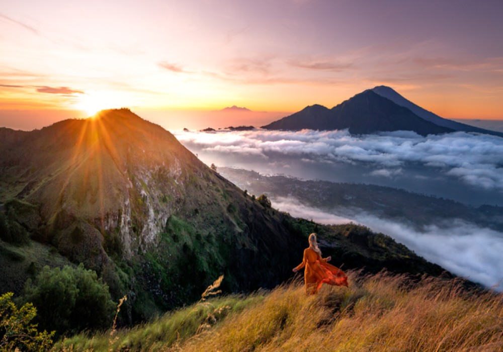
About the best timing to hike the Mount Batur in terms of a great sunrise, you have to be lucky depending on the season. We had a great sunrise with some low hanging fog in April. When we went in October it was completely clear without any clouds and we could see all the way until the volcanos in Lombok and East Java! If you want to have low hanging clouds the best months are July, August and September. The other months you have to be lucky to get a magical blanket of low hanging clouds which really makes you feel as if you’re in heaven! Always communicate with your guide about the best day to go up if you are flexible in your schedule. source
About Mount Batur
Mount Batur is a sacred stratovolcano in Bali of 1717 meters height located in Kintamani. Batur volcano is considered to be more than 50.000 years old and was even more than 4000 meters high before the first eruption 29,300 years ago. This eruption caused a collapse of the magma chamber that created two concentric calderas. Nowadays Mount Batur is marked by a collapsed top that is called a caldera.Mount Batur is still an active volcano but is highly monitored and safe to climb. The last eruption of Mount Batur was in 2000 and you can you see the wide lava fields that was created by the eruption. You can also explore the lava fields by foot, jeep or motorbike tour.
Mount Batur hike key facts
Before you set off for the Mount Batur hike, below some key facts! It’s important to know that there are two different routes to get up Mount Batur. The ‘longer’ but less steep version which takes about 1,5 hours one way and is 11 kilometres out and back. And the shorter but much steeper route which only takes about 45 minutes to 1 hour to reach the top and is 7 kilometres out and back. We did both routes, the longer version in April 2019 with the amazing tour guides of Four Elements Adventure and the shorter version in October 2021. You can also choose for camping on Mount Batur which is an unforgettable experience above the clouds!Hike distance and duration: The total distance of the Mount Batur hike is 7 kilometres out and back for the short route and 11 kilometres out and back on the longer route. The shorter route will take you anywhere between 45 minutes and 1 hour if you have a fast pace. The longer route will take you about double the time as you first trek a bit through the forest while on the shorter route you start already at a height of about 1250 meters at Pura Pasar Agung.
Difficulty and incline: The Mount Batur hike is done by many people, young and old. However, you do have to conquer incline and many uneven steps. The longer route has about 700 meters of inline over 11 kilometres of hiking. The shorter version has 500 meters of incline over 7 kilometres of hiking. I wouldn’t say the Mount Batur hike is difficult, it’s moderate but can be heavy at some points. It all depends on your fitness level and if you’re used to hiking. However, the view with sunrise is well worth the climb!
Best time to hike the Mount Batur
The best time to hike the Mount Batur volcano is in the dry season. Roughly from May until October, but any other period when it’s dry could be a good time. During the rainy season it might get dangerous as slides may arise or rocks can be slippery. That also brings us to the subject of wearing quality hiking shoes with good grip. But I’ll get more into that later with “What to prepare before you hike Mount Batur”. About the best timing to hike the Mount Batur in terms of a great sunrise, you have to be lucky depending on the season. We had a great sunrise with some low hanging fog in April. When we went in October it was completely clear without any clouds and we could see all the way until the volcanos in Lombok and East Java! If you want to have low hanging clouds the best months are July, August and September. The other months you have to be lucky to get a magical blanket of low hanging clouds which really makes you feel as if you’re in heaven! Always communicate with your guide about the best day to go up if you are flexible in your schedule. source
Latest Posts
-

Al contrario di quanto si pensi, LoClintock
26 Jun, 2024
-

-

Traduzione del 1914 di H. Rackham
26 Jun, 2024
-

-

Country is rapidly recovering from the impacts
26 Jun, 2024